April 2008
Tuesday, April 01, 2008 - Thunderstorms and hail
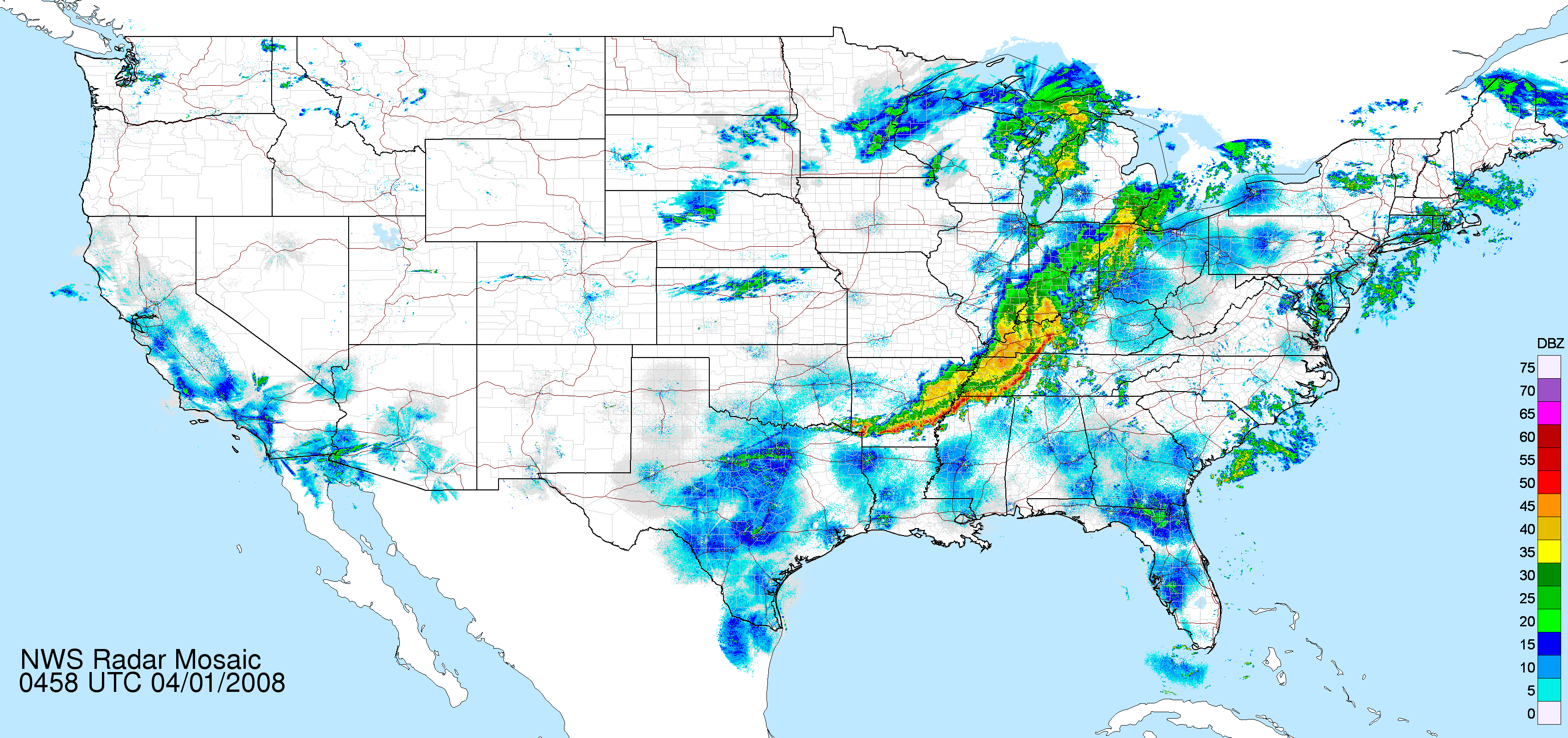
During the past 24 hours heavy thunderstorms raked the KPAH Region. Rainfall totals of 2-5 inches have been reported across almost the entire area. This is aggravating an already serious flood situation.
Here in Mayfield, Kentucky, we had a severe thunderstorm warning earlier on Monday Afternoon. Pea size hail fell here at the apartment. Another thunderstorm moved through Mayfield at 10:00 p.m. and caused pea to marble size hail. Winds gusted to 30 mph as well. No warnings were issued for that storm.
Early this morning, at 1 a.m., thunderstorms continued here in Mayfield, with heavy downpours. An urban and small stream advisory covers most of Western Kentucky.
It appears that another storm system will approach the region on Wednesday Night into Friday. Very heavy rains are expected from this weather maker. Severe thunderstorms will also be possible.
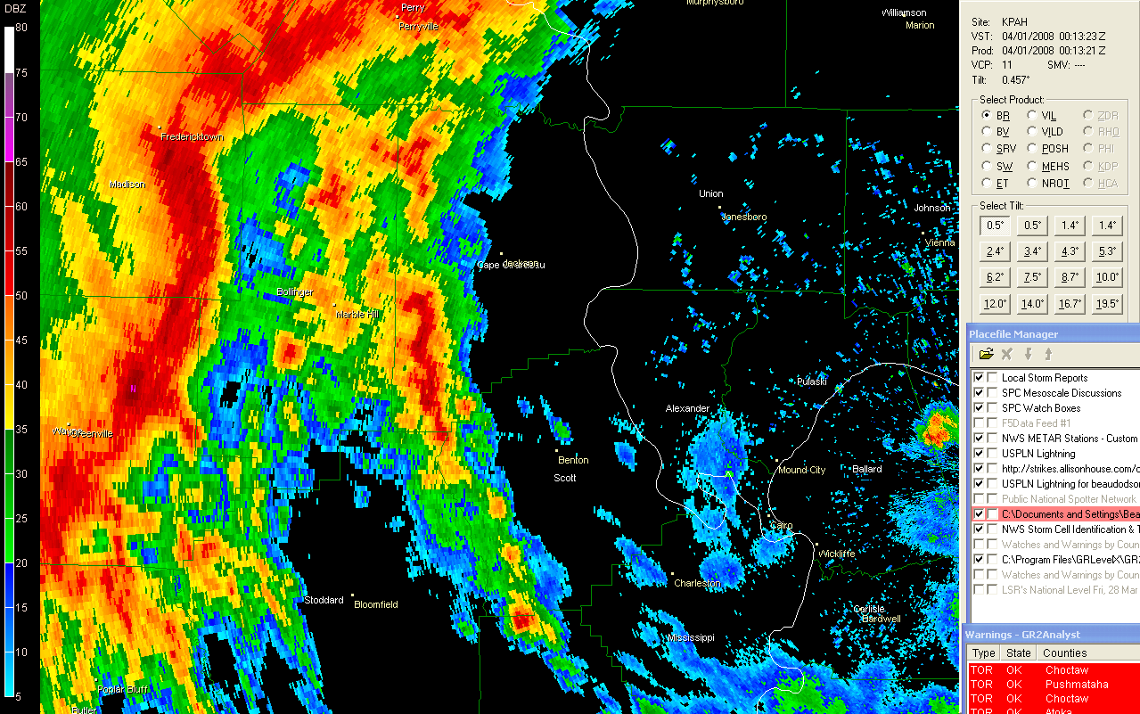
Radar Monday Evening 1 a.m. Radar
This was the warning that was issued for Graves County, Kentucky.
BULLETIN - IMMEDIATE BROADCAST REQUESTED
SEVERE THUNDERSTORM WARNING
NATIONAL WEATHER SERVICE PADUCAH KY
610 PM CDT MON MAR 31 2008
THE NATIONAL WEATHER SERVICE IN PADUCAH KENTUCKY HAS ISSUED A
* SEVERE THUNDERSTORM WARNING FOR...
GRAVES COUNTY IN WESTERN KENTUCKY
* UNTIL 700 PM CDT.
* AT 604 PM CDT...LOCAL LAW ENFORCEMENT REPORTED A SEVERE
THUNDERSTORM PRODUCING HALF INCH HAIL IN MAYFIELD. THIS STORM WAS
LOCATED NEAR MAYFIELD...MOVING NORTHEAST AT 40 MPH.
* LOCATIONS IN THE WARNING INCLUDE BUT ARE NOT LIMITED TO SYMSONIA.
IN ADDITION TO LARGE HAIL AND DAMAGING WINDS...CONTINUOUS CLOUD TO
GROUND LIGHTNING IS OCCURRING WITH THIS STORM. MOVE INDOORS
IMMEDIATELY.
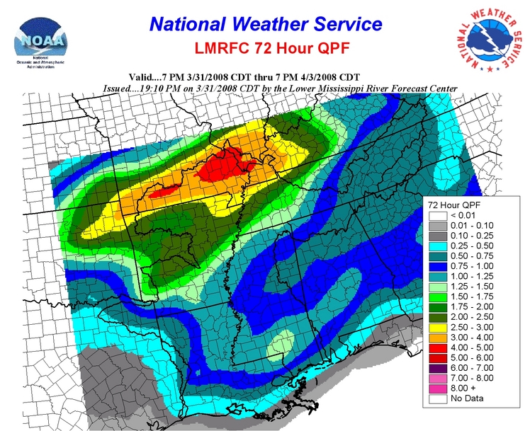
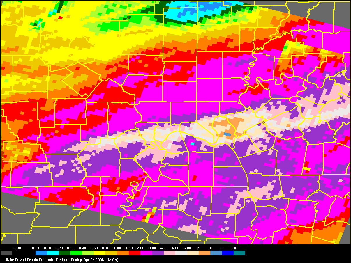
The map below is the rainfall forecast for the next five days. Impressive totals being forecast by the different models. The second map is the NAM rainfall forecast.
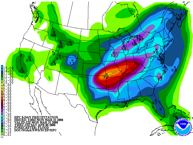
Rainfall forecast
Friday, April 04, 2008 - More Flooding
I don't believe I have ever witnessed so much rain across this region. Over the last 24 hours we have received 2"-8" of rain. The heaviest rain fell along the Ohio River counties. Once again Cape Girardeau County was hit hard. Massac County, Illinois also had serious flash flooding. Rainfall amounts across Massac County ranged from 3-6 inches.
Numerous counties were under flash flood warnings overnight. Yesterday afternoon there were also a number of severe thunderstorms in the region. Hail was reported with the severe storms. The freezing level was fairly low yesterday. Hail covered the ground near Vienna, Illinois.
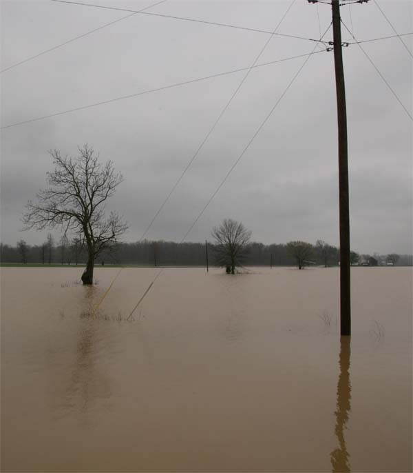
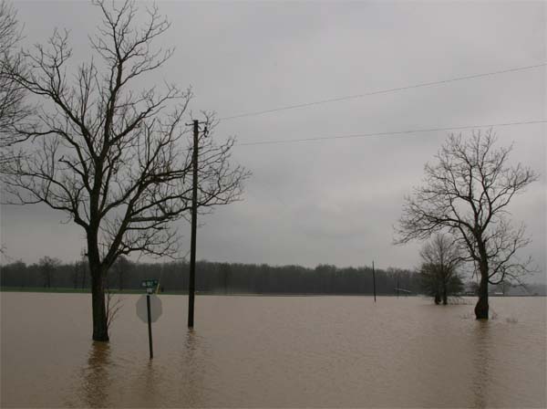
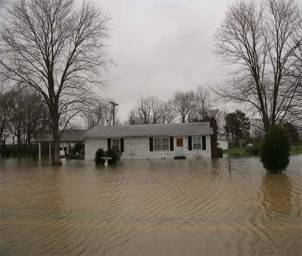
These photos are from Massac County, Illinois. Big Bay, Illinois. I took them earlier this afternoon.
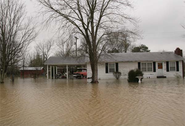
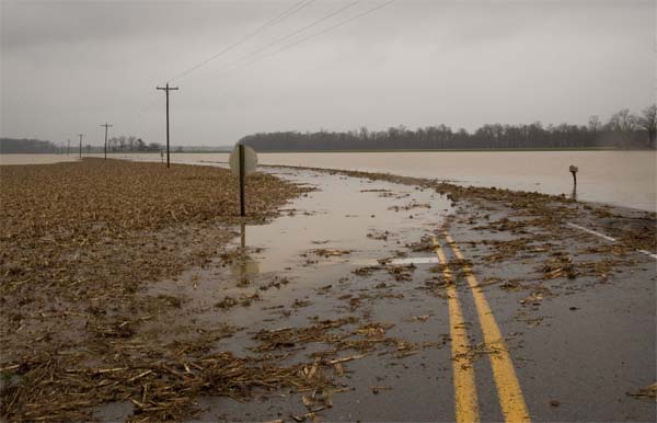
Big Bay, Illinois - Beau Dodson Photographs
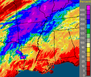
Paducah Rainfall Totals
Percentage Normal Rainfall
Rainfall Totals from the National Weather Service.
PUBLIC INFORMATION STATEMENT
NATIONAL WEATHER SERVICE PADUCAH KY
1144 AM CDT FRI APR 4 2008
...UNOFFICIAL 24 HOUR RAINFALL ACCUMULATIONS
WESTERN KENTUCKY:

PADUCAH ASOS...................4.09
OWENSBORO AWSS.................2.77
HOPKINSVILLE (COOP)............2.57
KENLAKE RESORT(COOP)...........2.82
MORGANFIELD (COOP).............4.25
MADISONVILLE 0.5 E (COCORAHS)..6.65
STURGIS 5.4 ENE (COCORAHS).....4.02
HANSON 2.2 NE (COCORAHS).......3.94
NORTONVILLE 0.5 NNE (COCORAHS).3.77
CONCORD 2.9 WSW (COCORAHS).....3.03
HENDERSON 0.4 SSW (COCORAHS)...2.41
SOUTHWEST INDIANA:

EVANSVILLE ASOS................2.19
GRANDVIEW (COOP)...............3.10
MOUNT VERNON (COOP)............2.16
STENDAL (COOP).................2.01
POSEYVILLE 2.8 NW (COCORAHS)...2.97
EVANSVILLE 3.9 ESE (COCORAHS)..2.89
NEWBURGH 2.4 NW (COCORAHS).....2.80
EVANSVILLE 1.3 SSE (COCORAHS)..2.73
CHANDLER 1.1 S (COCORAHS)......2.44
BOONVILLE 1.4 N (COCORAHS).....2.38
CHANDLER 4.4 WSW (COCORAHS)....2.35
EVANSVILLE 5.9 WNW (COCORAHS)..2.26
DARMSTADT 4.4 SSW (COCORAHS)...2.25
MELODY HILL 2.9 WNW (COCORAHS).2.19
EVANSVILLE 3.0 N (COCORAHS)....2.12
OWENSVILLE 0.1 SW (COCORAHS)...2.07
PETERSBURG 1.4 ENE (COCORAHS)..1.64
SOUTHEAST MISSOURI:

CAPE GIRARDEAU ASOS............3.82
POPLAR BLUFF ASOS..............3.16
CLEARWATER (COOP)..............1.58
JACKSON (COOP).................2.46
DONIPHAN (COOP)................2.92
POPLAR BLUFF (COOP)............2.85
WAPPAPELLO (COOP)..............2.15
ZALMA (COOP)...................5.11
LAMBERT 0.8 ESE (COCORAHS).....4.05
BLOOMFIELD 2.9 S (COCORAHS)....3.61
ANNISTON 1.9 WNW (COCORAHS)....3.32
JACKSON 1.1 NE (COCORAHS)......3.27
POPLAR BLUFF 4.2 NW (COCORAHS).2.80
WHITEWATER 3.4 W (COCORAHS)....2.47
MARBLE HILL 0.4 NE (COCORAHS)..2.26
JACKSON 2.3 WNW (COCORAHS).....2.23
JACKSON 1.0 SW (COCORAHS)......1.95
NEW MADRID 0.3 SE (COCORAHS)...1.28
PERRYVILLE 1.1 NE (COCORAHS)...1.10
SOUTHERN ILLINOIS:

CARBONDALE ASOS................2.11
BROOKPORT DAM (COOP)...........4.14
CARBONDALE (COOP)..............2.70
CAIRO (COOP)...................3.87
GRAND CHAIN DAM (COOP).........6.43
GRAYVILLE (COOP)...............1.55
GRAND TOWER (COOP).............1.43
MOUNT VERNON (COOP)............0.94
SMITHLAND DAM (COOP)...........3.02
RIDGWAY 3.8 NE (COCORAHS)......2.67
ANNA 3.1 NNE (COCORAHS)........2.43
BUSH 2.0 ESE (COCORAHS)........2.11
HURST 0.2 SSE (COCORAHS).......1.95
BENTON 5.3 NNE (COCORAHS)......1.67
GRAYVILLE 1.1 N (COCORAHS).....1.55
WALTONVILLE 3.4 WSW (COCORAHS).1.03
CISNE 4.0 E (COCORAHS).........0.98
$$
ASOS: AUTOMATED SURFACE OBSERVATION SYSTEM
AWSS: AUTOMATED WEATHER SENSOR SYSTEM
COOP: COOPERATIVE OBSERVER
COCORAHS: COMMUNITY COLLABORATIVE RAIN...HAIL AND SNOW NETWORK
Sunday, April 06, 2008 - Severe Weather Threat?
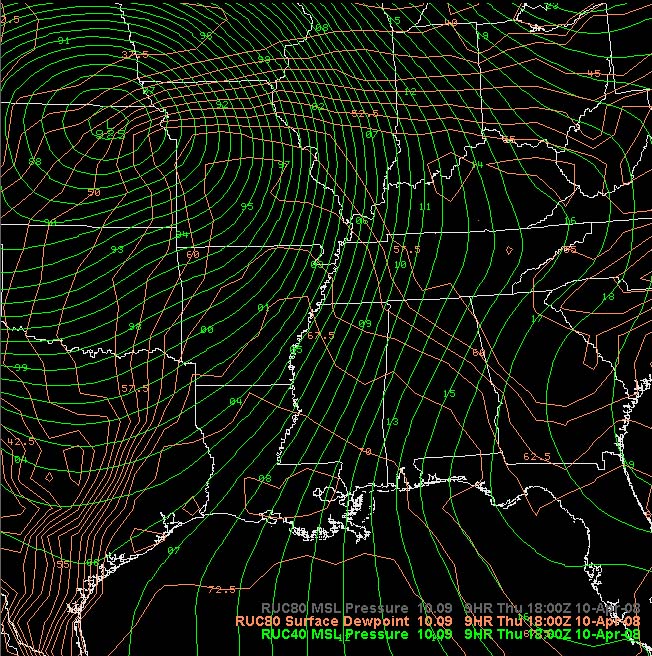
Spring has arrived and with it will come a risk for severe thunderstorms. It appears we will be facing two significant threats for strong to severe storms. The first threat will arrive on Tuesday Evening with an area of low pressure coming out of Oklahoma. The low will track through Missouri and into Illinois on Wednesday morning.
Soundings from Paducah, Kentucky indicate that there will be sufficient instability and wind veering to produce supercell thunderstorms. I believe there will be a threat for tornadoes across portions of Eastern Arkansas, Western Tennessee, Eastern Missouri, Western Kentucky, Central and Southern Illinois, and Southwest Indiana.
The Storm Prediction Center has placed the region in a slight risk for severe thunderstorms, on their day 3 outlook.
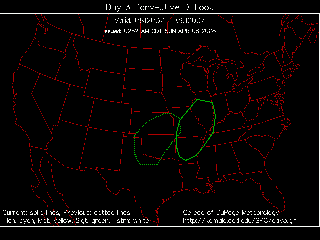
Day 3 Outlook from SPC.
The second risk will come on Thursday and Thursday night - possibly into Friday. This will be a stronger system with the potential for a widespread severe weather event.
Sunday, April 11, 2008
Both severe weather events did not live up to expectations this week. The biggest concern was Thursday when it appeared that a major outbreak was going to hit this region. Thankfully, that did not materialize. There were a few reports of severe weather across the KPAH region. Not many though.
I worked the event for 18 straight hours. The first tornado watch was issued during the early morning hours. I started watching radar at 5 a.m. and finished at midnight. No warnings were issued for McCracken County. Numerous strong storms did develop though ahead of a trough of low pressure.
All of our counties were placed under a moderate risk of severe thunderstorms, by the Storm Prediction Center. Two tornado watches also covered the region - they were in effect all day and expired at 11 p.m. Thursday night.
Powerful low
Verification for the event from the Storm Prediction Center.
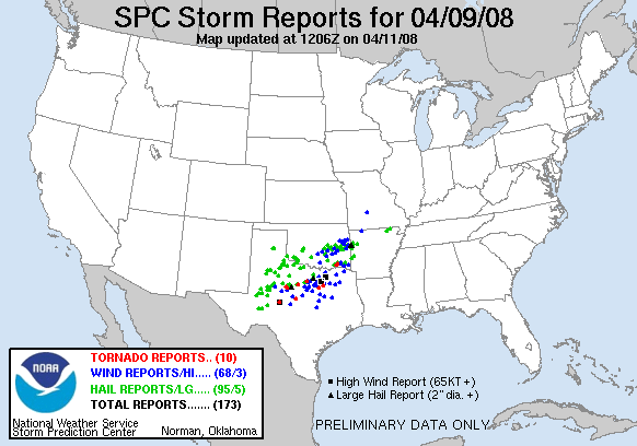
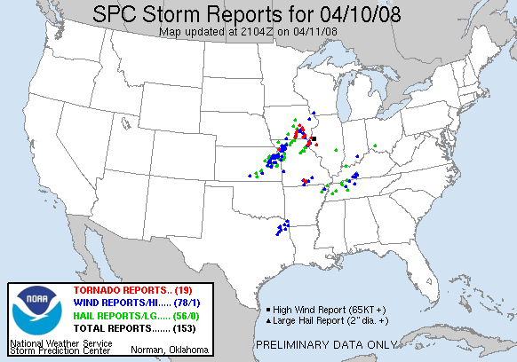
April 09-10, 2008 Severe Storms
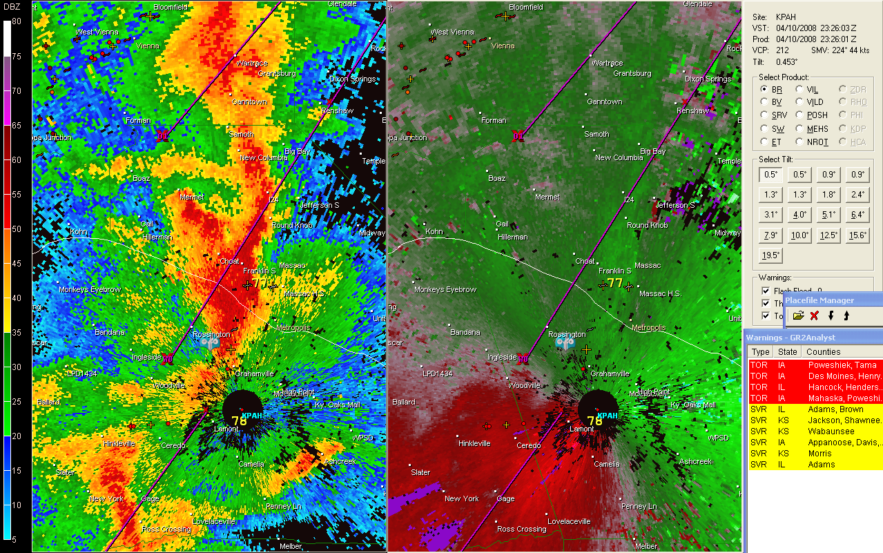
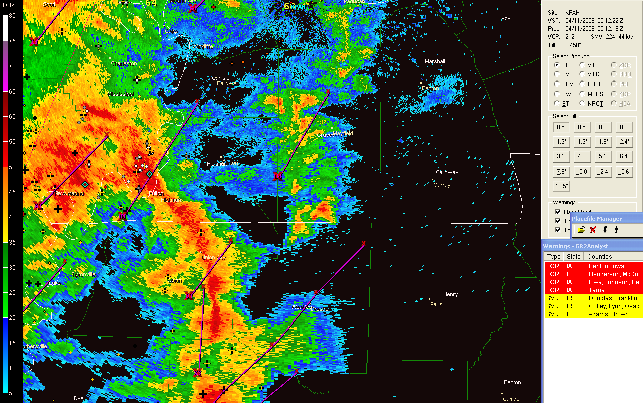
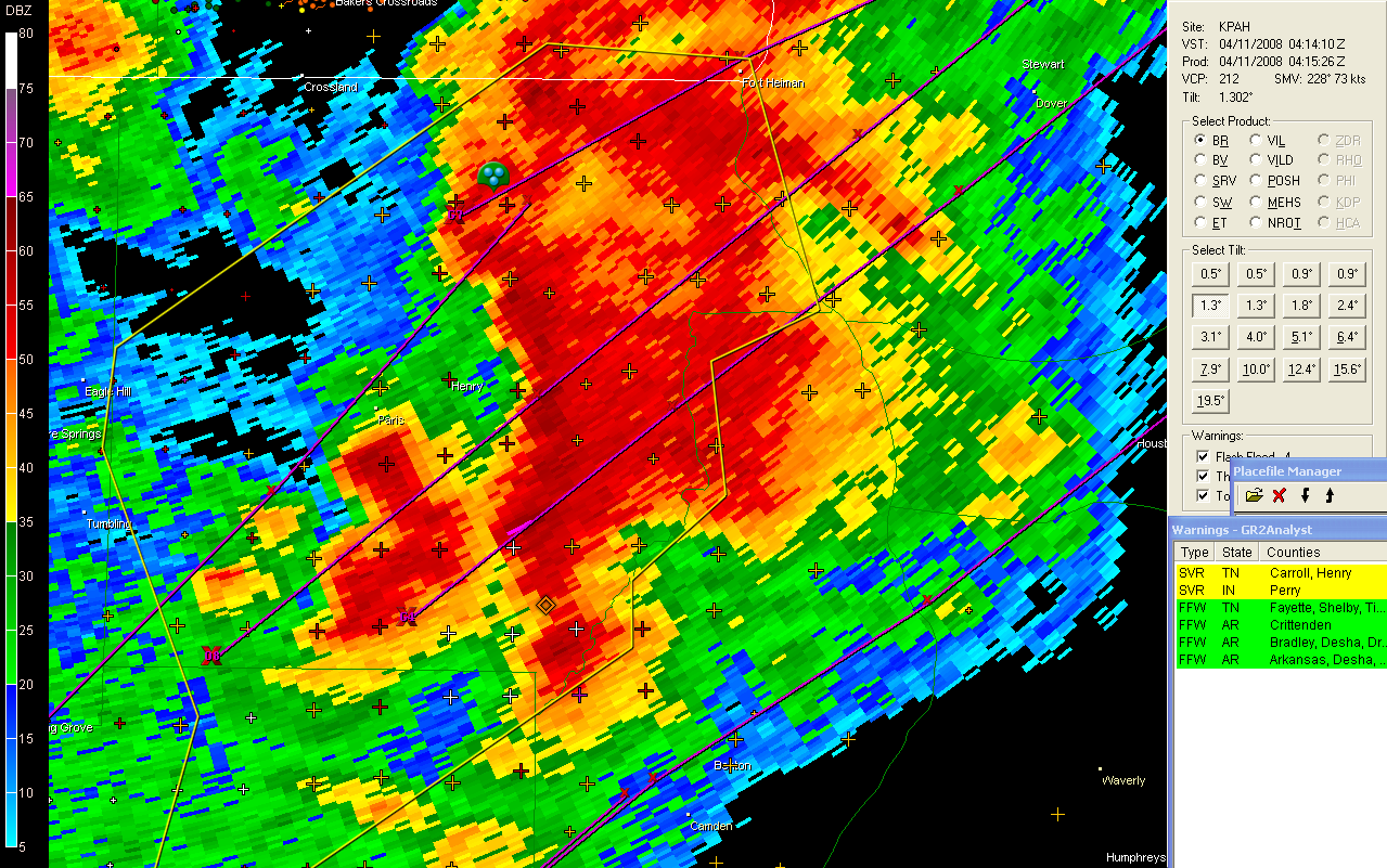
Radar shots from Paducah, KY and Memphis, TN
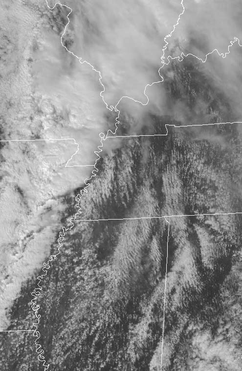
Storms forming Blowing dust
Sunday, April 20, 2008
I have started a new web site for those interested in "armchair" chasing. Lot of chaser news and links.
www.stormreports.org/
The new site
Quiet weather? Where has the weather gone! I guess quiet weather in April isn't a bad place to be. The flooding has been horrendous. The one saving grace has been the fact that we have not had a major severe weather outbreak. The last event was a bust. So that is good news for everyone who was dreading another outbreak in this region. Long way to go though...May will be active.
Check out the rainfall averages - we are WAY WAY WAY above normal.
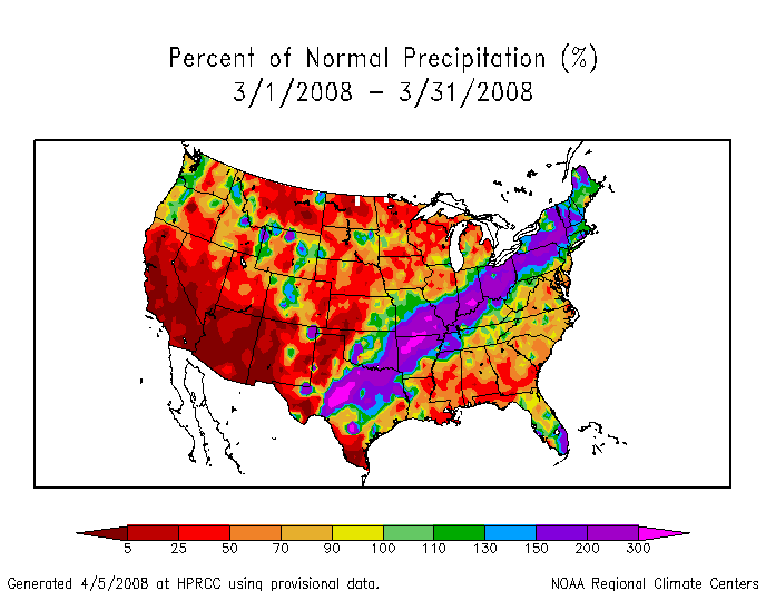
Click for full image
Beautiful weather today. Temperatures are in the 70s with a bright blue sky. Couldn't ask for a nicer spring day.
April 23, 2008
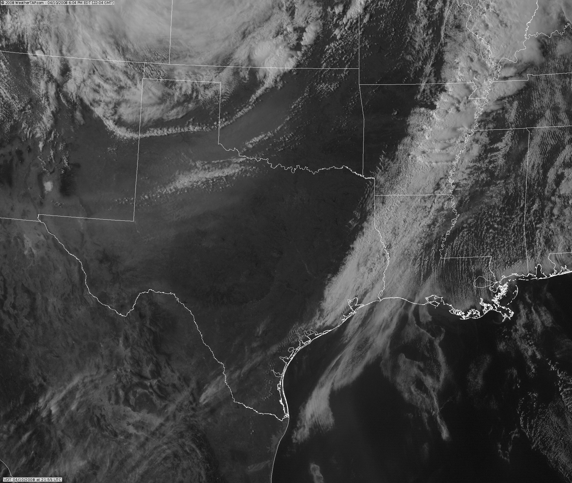
Calm weather across our region over the last few weeks. Unusual for spring. There were some severe thunderstorms across the Central United States. Here is a satellite photo of the tornadic storms in Texas.

April 29, 2008
It appears that there will be a threat for some severe weather on
Thursday and Friday. A deep low will pull out of the Central
Plains. There could be a second low form on Friday. We will
have to watch the moisture return. The Gulf of Mexico has been
scoured out over the last few days. The Storm Prediction Center
has placed a risk over portions of KS, OK, MO, and AR. This would
be for the Thursday time period.
Turn the page for more weather
Home | About | News | Upcoming Events| Photo Gallery | Video | Links | Contact
All Photos are copyrighted by Beau Dodson (unless otherwise clearly stated) and are used on this site with his permission. Any use other than authorized by them is against the law. If you wish to contact him regarding use of these photos, please e-mail me and I will forward it.