August 3, 2007
Portions of South Asia have been
hit with one of the worst flooding events in recent memory. More
than fifty percent of Bangladesh is currently under water. At least 20
million people have been displaced by the flooding and hundreds have
perished. Flooding is expected to worsen in the coming days.

Here in Zurich, Switzerland the weather continues to be cooler than normal. Scattered rain showers have fallen in the city over the last few days. Squally weather as well from time to time. The city and adjoining countryside are beautiful though and I could certainly see living in this region (at least part of the year). I will be here in Zurich until Monday.
August 4, 2007
Snow in August? Swiss Alps.
Today was spent in the Swiss Alps. Perfectly clear skies provided a beautiful setting for a helicopter ride to the top. A number of mountain climbers could be seen exploring the different peaks around the White Horn and the Matter Horn. I was able to fly the helicopter for about 15 minutes during our trip back to Zurich. We landed on one of the mountain peaks and were greeted with beautiful-pristine snow! We were close to 3000 meters above sea level when we landed.

Flying through the Swiss Alps.

The White Horn

My first August snow!


The temperature at this location was 10 degrees
Celsius. Fairly warm for 3000 meters. We even saw a butterfly.
It must have gotten itself caught up in a current. Unfortunately
if it landed in the snow then it probably did not survive. They
tend to freeze almost instantly in ice or snow.
August 5, 2007
I am in Luzerne, Switzerland today. The
weather conditions are simply amazing. One might think it was late
summer or early fall. Temperatures are near 80 degrees with a
light breeze. Overnight lows were in the upper 50s. The
region had snow two weeks ago all the way down to 2000 meters. One
could not ask for better weather though this week. There were a
lot of people out on Lake Luzerne boating and enjoying the day.

Lake Luzerne
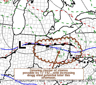
August 7, 2007
Strong to severe thunderstorms are possible today
across this area. Waterloo and most of Southern Ontario is under a
slight risk for severe storms. The Storm Prediction Center
indicates that there could be isolated tornadoes. Radar this
morning at 7 a.m. is showing a large area of showers and thunderstorms
extending from near Detroit westward into Nebraska. A severe
thunderstorm watch has been issued for part of Southern Ontario.
It is cloudy here in Waterloo at 7
a.m. Clouds have been lowering and thickening over the past few
hours.
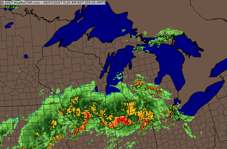
Weathertap Radar - 7:15 a.m.
Light to Moderate rain fell in Waterloo from 11 a.m. through 1 p.m. There were several close lightning strikes here at the house. Most of the severe weather, so far today, has stayed to our south. Additional thunderstorms may develop later this afternoon and evening.
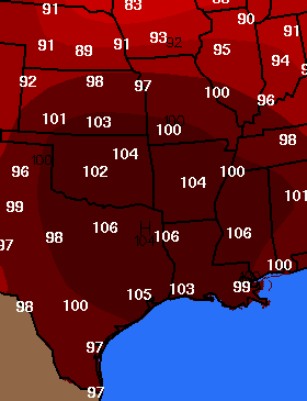
Meanwhile, across the Ohio Valley, a killer heat wave continues to bring temperatures in the 90s and over 100 degrees. Many areas are experiencing Heat Index Values between 100-110 degrees. Dangerous temperatures for those who have to remain outdoors.
Temperature Map, from Wright-Weather, at 2 p.m. Eastern Time - Click to enlarge - Also the National Weather Service Warning Map is showing a huge area under Heat Advisories and Excessive Heat Warnings (red and pink areas).
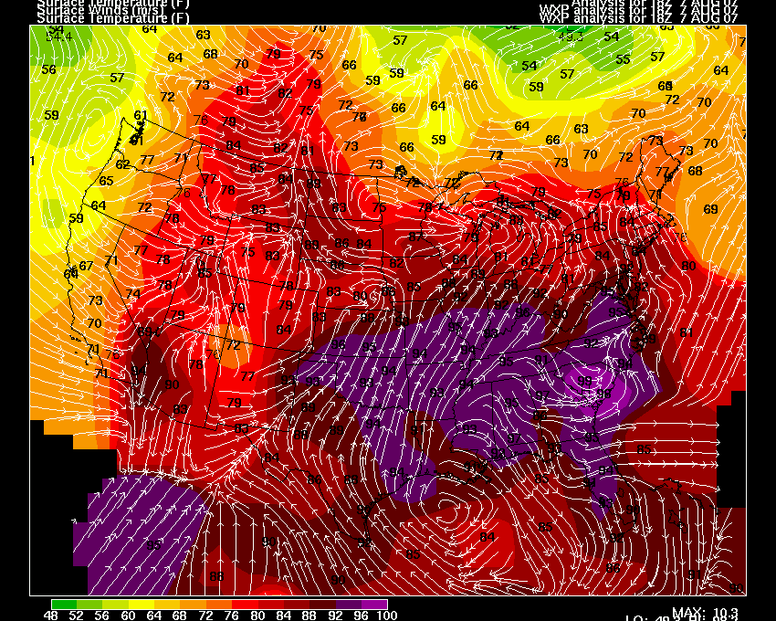
At 1 p.m. the temperature was 96 degrees at both Paducah, Kentucky and
St Louis, Missouri. Heat Index Values were over 100 degrees in
both cities.
August 8, 2007
Possible Tornado hits New York City/Brooklyn
A possible
tornado this morning in the Queens Area of New York, City. The
NWS issued a tornado warning for the Bay Ridge Area around 6:15 this
morning. The storm then moved through the Queens area. A
tornado warning was extended for the area around Kennedy Airport.
There have been reports of roofs blown off of houses, trees down,
windows blown out, and other significant damage in the Bay Ridge
Neighborhood. Residents report hearing a loud roar when the storm
hit. The NWS is investigating to determine whether straight line
winds or a tornado is to blame for the damage.
Some photos of the damage can be viewed on this site. Some
additional high
resolution radar images of this mornings storm.
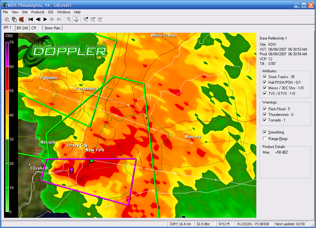 |
 |
| Radar Image by whiteoutwx1776 - EasternUSwx | Location Map |
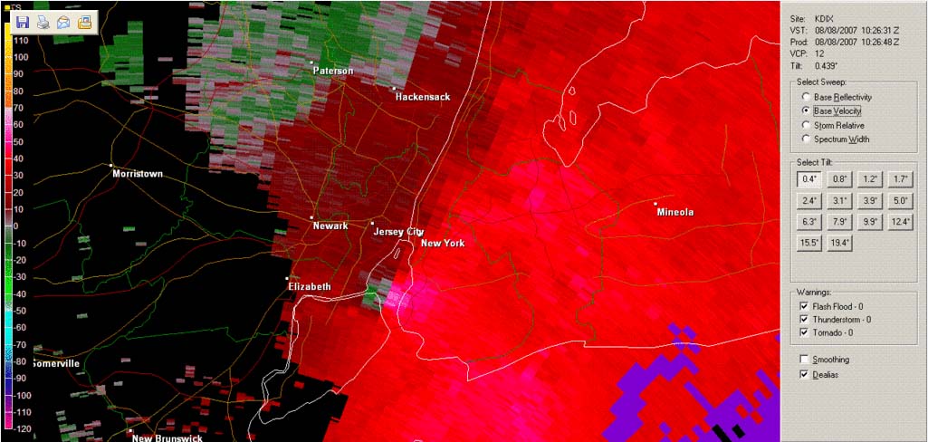
Couplet as indicated by GRAE Level 2 Data - posted
by turtlehurricane
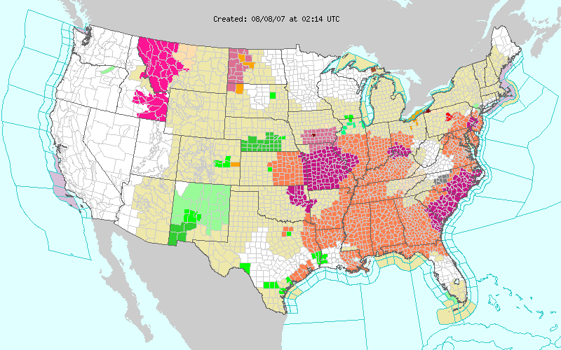
Severe thunderstorms raked portions of the
Missouri Valley, northern Plains, and the Northeast on Wednesday.
Dunn County, Nebraska reported winds of 72 mph in a thunderstorm.
Numerous other reports of high winds were received from Pennsylvania.
Including damage to four houses in Scranton, Pennsylvania. Many
trees were downed from the storms in numerous other towns and counties
across portions of Pennsylvania, Northeast Ohio, and New Jersey.
The National Weather Service issued numerous severe thunderstorm
warnings and a handful of tornado warnings. No confirmed tornado
reports were received.
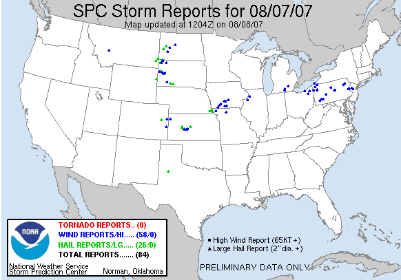
Tuesday SPC Severe Weather Reports
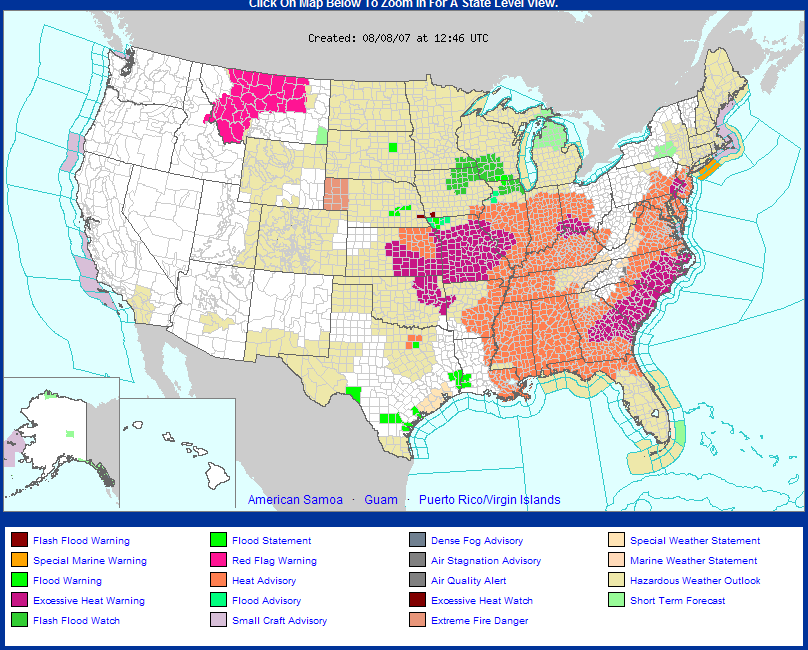
Wednesday NWS Warning Map
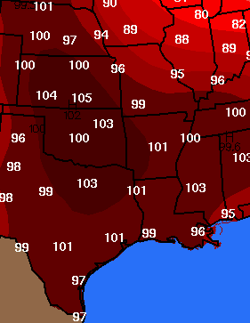
Extreme heat will continue today across much
of the Central and Eastern half of the United States. Temperatures
will soar into the 90s and lower 100s. The National Weather
Service has issued heat warnings and advisories for more than 22 states.
At 4 p.m. it was 100 degrees in Paducah, KY and 102 degrees at the
Louisville, Kentucky National Weather Service Office. Heat Index
readings are between 105-110 degrees.
RECORD EVENT REPORT
NATIONAL WEATHER SERVICE PADUCAH KY
305 PM CDT WED AUG 8 2007
...RECORD DAILY MAXIMUM TEMPERATURE SET AT PADUCAH ASOS...
WITH THE PERSISTENT HEAT WAVE OVER MUCH OF THE MID MISSISSIPPI AND
LOWER OHIO RIVER VALLEYS...AFTERNOON HIGH TEMPERATURES CONTINUE TO
BE 10 TO 15 DEGREES ABOVE NORMAL IN MANY COMMUNITIES.
TODAY AT 255 PM..A TEMPERATURE OF 100 DEGREES WAS RECORDED ON THE
BARKLEY REGIONAL AIRPORT ASOS, IN PADUCAH KENTUCKY. THIS SETS A NEW
RECORD FOR THIS DATE. THE OLD RECORD WAS 99 DEGREES, WHICH WAS
RECORDED ON THIS DATE IN 1998.
THE LAST OCCURRENCE OF 100 DEGREES AT PADUCAH KENTUCKY WAS ON SEP
5TH, 1999. THE HIGHEST TEMPERATURE RECORDED DURING THE MONTH OF
AUGUST IS 106 DEGREES, WHICH OCCURRED ON AUGUST 4TH, 1947. THE
ALL-TIME MAXIMUM TEMPERATURE RECORDED IS 108 DEGREES, RECORED ON
JULY 17TH, 1942.
SMITTY
82 degrees here in Waterloo, Ontario. A nice breeze today. Clouds have been thickening this afternoon. No rain is in the forecast through tonight. There will be a 40% chance of rain on Thursday. I will be driving back to Western Kentucky tomorrow.
Brooklyn Storm Update...EF-2 Tornado
The NWS has determined that a tornado did touch down this morning in New York City. They have rated the storm as an EF-2.
PUBLIC INFORMATION STATEMENT
SPOTTER REPORTS
NATIONAL WEATHER SERVICE UPTON NY
512 PM EDT WED AUG 8 2007
...NATIONAL WEATHER SERVICE METEOROLOGISTS CONFIRM EF2 TORNADO
TOUCHDOWN IN BAY RIDGE AND VICINITY IN BROOKLYN...
NATIONAL WEATHER SERVICE METEOROLOGISTS INVESTIGATING STORM DAMAGE
IN THE BAY RIDGE AREA WITH NEW YORK CITY EMERGENCY MANAGEMENT
OFFICIALS HAVE CONFIRMED THAT TORNADIC DAMAGE HAS OCCURRED IN THE
AREA.
THE TORNADO PATH WAS DISCONTINUOUS AND STARTED IN BAY RIDGE
SOMETIME JUST AFTER 6:30 AM TODAY ON BAY RIDGE AVENUE BETWEEN THIRD
AND FOURTH AVENUES...AND CONTINUED ON AN EAST-NORTHEAST PATH ACROSS
68TH STREET BETWEEN THIRD AND FOURTH AVENUES. ELEVEN HOMES IN THIS
SECTION HAD MODERATE TO SEVERE ROOF DAMAGE. THE STORM CONTINUED TO
MOVE EAST-NORTHEAST INTO LEIF ERICSON PARK SQUARE...WHERE SEVERE
DAMAGE TO TREES OCCURRED. AS THE TORNADO LIFTED...IT TORE OFF THE
ROOF OF THE NISSAN CAR DEALERSHIP AT THE CORNER OF 66TH STREET AND
FIFTH AVENUE. THE TORNADO RETURNED TO THE GROUND FARTHER
NORTHEAST...WITH SCATTERED TREE DAMAGE ALONG 6TH AVENUE. BASED ON
THE ASSESSED DAMAGE...THIS TORNADO IS CLASSIFIED AS AN EF-2 TORNADO
WITH ESTIMATED WIND SPEEDS OF 111 TO 135 MPH.
THE TORNADO RETURNED TO THE GROUND AS ANOTHER POCKET OF SIGNIFICANT
DAMAGE OCCURRED ON 58th STREET BETWEEN FIFTH AND SIXTH AVENUES.
THE ROOF WAS RIPPED OFF OF 5 HOMES...AND TREE DAMAGE INDICATES STRONG
EF-1 DAMAGE...WITH WINDS OF 86-100 MPH.
THE NATIONAL WEATHER SERVICE HAD ISSUED A TORNADO WARNING FOR THIS
STORM AT 6:28 AM.
JC
Evening Update...Kansas and Missouri Severe Weather
8:40 p.m. Central Time Kansas City Radar
Severe thunderstorms are raking portions of Nebraska, Missouri, and Kansas this evening. Wind gusts over 70 miles per hour have been reported at several locations. Major damage has been reported in Atchison County, Missouri where straight line winds or a possible tornado struck earlier tonight.
PRELIMINARY LOCAL STORM REPORT
NATIONAL WEATHER SERVICE KANSAS CITY/PLEASANT HILL MO
805 PM CDT WED AUG 08 2007
0700 PM TSTM WND DMG SE
FAIRFAX COUNTY
08/08/2007
ATCHISON MO
REPORTED BY EMERGENCY MNGR
EMERGENCY
MANAGER REPORTS MASSIVE BLOW DOWN ACROSS
SOUTHERN
ATCHISON COUNTY FROM FAIRFAX TO THE COUNTY LINE.
WIDESPREAD
TREES AND POWER POLES DOWN. ENTIRE CORN FIELDS
MOWED DOWN BY
STRAIGHT LINE WINDS.
BOOKBINDER
August 9, 2007
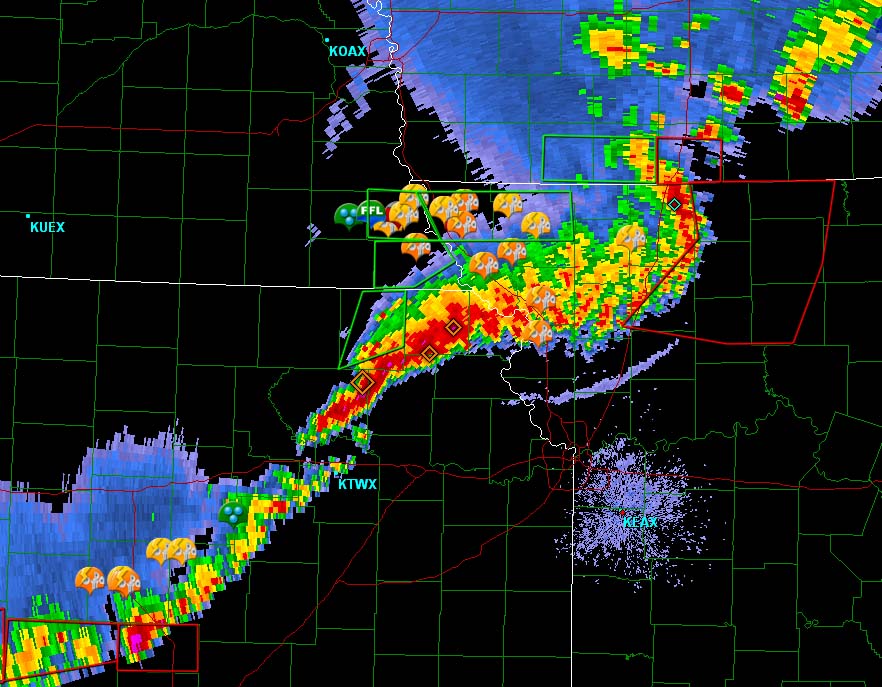
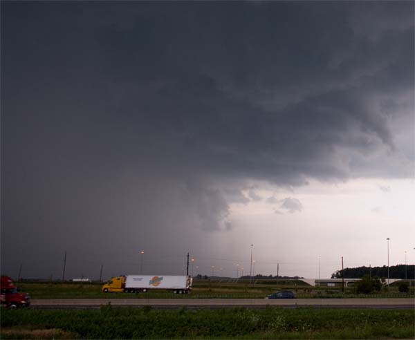
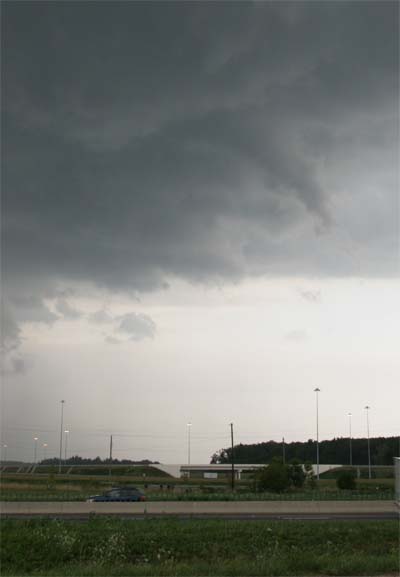
Ohio Storm Chase
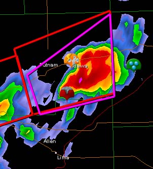
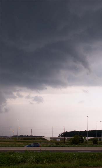
Thunderstorms that produced significant wind damage and tornadoes moved across portions of Ohio this morning and afternoon. I was fortunate enough to be in the right spot at the right time to capture a tornado warned cell in Putnam and Allen Counties. The NWS first issued a severe thunderstorm warning and quickly upgraded it to a tornado warning. We saw the tower go up to our west and it quickly exploded into a severe thunderstorm. We saw several funnel clouds and extremely heavy rain. Winds gusted to approximately 40 miles per hour during the storm. I took these photos off of Interstate 75 in extreme northern Allen County.

Click for radar image - we were near the
tornado icon on the radar grab. Image grab
from Jason Darnell.
Ohio tornadoes...August 9, 2007 -
Gibson Ridge
Radar image provided by Jason Darnall
Gibson Ridge
Radar Loop - Large Image Animation
Radar Animation
- provided by Jason Darnall
Satellite Animation -
You can see the storms explode in Northwest Ohio. WeatherTap
animation provided by Jason Darnall.

Mammatus Clouds make for a stormy sky
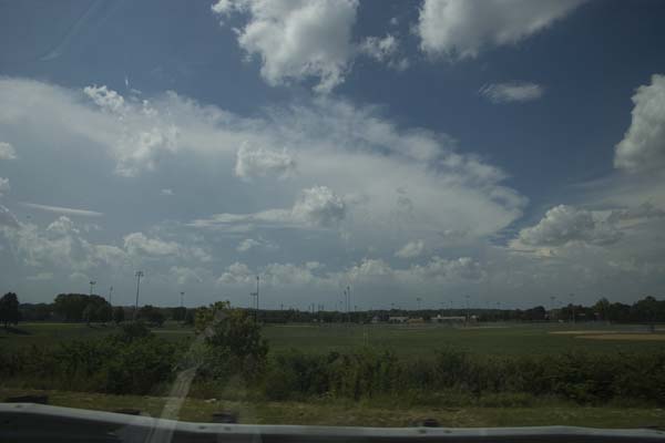
A line of severe thunderstorms builds across Ohio
Funnel cloud dips down over Interstate 75 in Allen
County, Ohio.
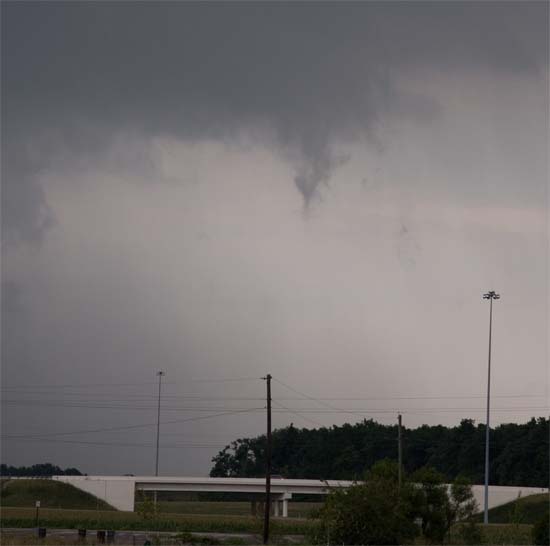
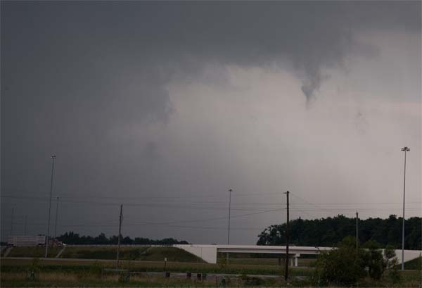
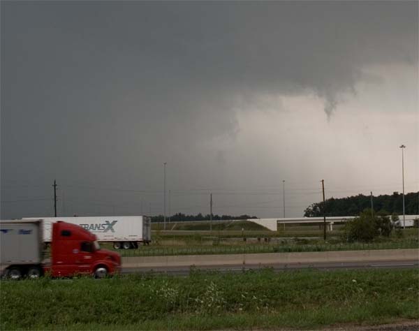
Funnel Cloud
Funnel Cloud
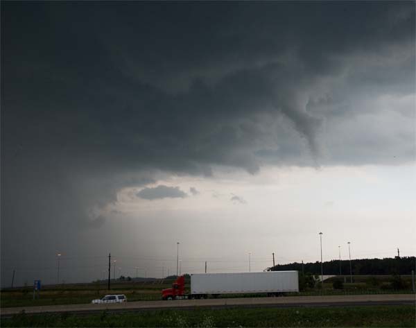
Funnel Cloud
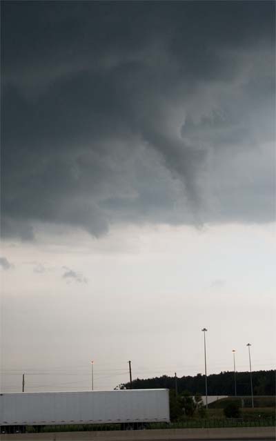
Funnel Cloud over Interstate 75 in Allen County,
Ohio
BULLETIN - EAS ACTIVATION REQUESTED
TORNADO WARNING
NATIONAL WEATHER SERVICE NORTHERN INDIANA
221 PM EDT THU AUG 9 2007
THE NATIONAL WEATHER SERVICE IN NORTHERN INDIANA HAS ISSUED A
* TORNADO WARNING FOR...
EASTERN PUTNAM COUNTY IN WEST CENTRAL OHIO
* UNTIL 300 PM EDT
* AT 219 PM EDT...NATIONAL WEATHER SERVICE DOPPLER RADAR INDICATED A
SEVERE THUNDERSTORM WITH STRONG
ROTATION. THIS SEVERE STORM WAS LOCATED
NEAR COLUMBUS GROVE...OR ABOUT 7 MILES SOUTH OF OTTAWA...
AND MOVING
EAST AT 10 MPH.
* LOCATIONS IN THE PATH OF THE SEVERE STORM INCLUDE...
GLANDORF...
OTTAWA...
PANDORA...
GILBOA AND LEIPSIC...
We ended up being right near the wall cloud and funnel clouds. The
whole system lined out fairly quickly. The main funnel cloud showed some
strong rotation but it only last about 5 minutes.
Here
are some photos taken and posted by Anthony Scaglione on EasternUSwx.
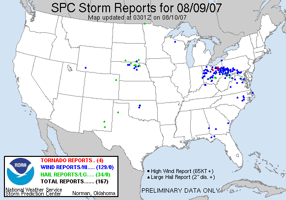
Severe Weather Reports
The Storm Prediction Center issued a Severe Thunderstorm Watch for a large portion of Ohio.
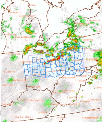
DISCUSSION...STORMS HAVE BEEN INTENSIFYING ALONG A
LOW LEVEL BNDRY ACROSS NERN OH...AND THERE IS POTENTIAL FOR NEW STORMS
TO DEVELOP WWD ACROSS PARTS OF WRN OH IN ADVANCE OF SEVERAL MCV FEATURES
MOVING ACROSS SRN LOWER MI AND INDIANA. RELATIVELY CLEAR SKIES
HAVE ALLOWED TEMPERATURES TO WARM TO NEAR 90F...AND WITH DEW POINTS IN
THE LOW 70S AIR MASS IS MODERATELY UNSTABLE WITH MLCAPE OF 1500-2500
J/KG. WESTERLY MID LEVEL WINDS OF 30-40 KT ARE CONTRIBUTING TO
SUFFICIENT DEEP LAYER SHEAR TO ENHANCE STORM ORGANIZATION. WARM
MID LEVEL TEMPERATURES/HIGH FREEZING LEVELS MAY TEMPER HAIL THREAT BUT
STEEP LOW LEVEL LAPSE RATES WILL ENHANCE THREAT FOR DAMAGING WIND GUSTS.
...WEISS
The Storm Prediction Center also issued this mesoscale discussion concerning the squall line.
Also more intense heat covered the Ohio Valley.
Paducah, Kentucky set a new record high again this afternoon. This
was the second day in a row for a new record high temperature in
Paducah. RECORD EVENT REPORT It is difficult to explain to people why we love
weather. Many have tried. Many chasers have made
attempts. Most fall short though. Perhaps because you have
to have been bitten by the weather bug in order to understand the
obsession. It is something that is in
us. Consumes us. Makes us want more. What is it about
the anticipation of a blinding snowstorm that drives us to sit in front of our computer
monitors for hours on end? What is it about the boiling sky that
causes are blood to rush through our bodies like the Euro-train through
the grasslands of France? Why does our heart skip a beat when the
weatherman mentions the word tornado or hurricane? Could it be our
desire to tame the untamable? Perhaps it is our childlike wonderment of
white flakes falling from the sky? Closing schools and businesses.
Turning adults into children! It could be the challenge of constantly
trying to understand something that simply can't be understood.
The processes of nature. That which is beyond our control.
Beyond our ability to rule over. We are so used to being in
control. Perhaps this is why we love weather. There is nothing more beautiful than the sun
setting in the evening with a sky full of mammatus clouds boiling
downward. There are hundreds if not thousands of colors.
Rich shades of purple,
deep orange, red, and yellow. Constantly changing as the sun grows
lower and lower on the horizon. What is more beautiful
than a million snowflakes clinging to a tree - illuminated only by the
moons golden light? It is almost as if someone took a hand full of
powdered sugar and tossed it into the air...landing gracefully on each
branch - each leaf. Painting it white. It almost appears to
have purpose. That there is some rhyme or rhythm to the design. A
creation that could only be made by a master artist. Perhaps we love weather and the amazing power
of weather because it is the one thing in life that is more powerful
than man-kind. To stand in front of a tornado...a hurricane...a
bolt of lightning. The raw power. The incredible sensation
that your body feels when you realize just how small we are. How
insignificant we truly are.
Standing in a farmers field...watching a wall cloud twisting above you. It is
that moment that we realize that there is more to life than just
computers, televisions, money, and possessions. It is in those few
still moments that you stand alone in front of mother nature - just you
and her. Watching and waiting...wondering what she will do next.
It isn't the destruction. It isn't the death tolls. It isn't
the pain and suffering that unfolds before us. That, of course, is not why we
love weather or what we are looking for. Those consequences of nature are beyond our control.
Mother nature never asked us to build on her shores and beaches.
She never asked us to place our homes where the flood waters rage.
She simply does what she has always done...for millions of years.
If we happen to capture that on film...if we happen to witness that with
our eyes then there is no shame in that. The weather will do what
the weather will do. We do not control any part of it. I chase to capture the beauty of it all.
To capture something that will never be repeated again. Every
snowstorm is different, every hurricane is different, every supercell is
different. I rarely, although I do from time to time, photograph
the consequences of weather {damage). If I am being asked (Red
Cross, EOC, NWS or other) to record an event then I will do it. I
don't like doing it though. This is why most of my photographs are
simply of nature rather than the consequences of nature.
Having had friends who lost loved ones in tornadoes I am extremely
sensitive to this topic. I do think it can be explained though, in
a way that helps people understand what we love about weather.
Beau
NATIONAL WEATHER SERVICE PADUCAH KY
430 PM CDT THU AUG 9 2007
...RECORD DAILY MAXIMUM TEMPERATURE TIED AT PADUCAH ASOS...
WITH THE PERSISTENT HEAT WAVE OVER MUCH OF THE MID MISSISSIPPI AND
LOWER OHIO RIVER VALLEYS...FOR A SECOND CONSECUTIVE DAY...RECORD
SETTING AFTERNOON HIGH TEMPERATURES CONTINUE TO BE 10 TO 15 DEGREES
ABOVE NORMAL IN MANY COMMUNITIES.
TODAY AT 411 PM..A TEMPERATURE OF 99 DEGREES WAS RECORDED AT THE
BARKLEY REGIONAL AIRPORT ASOS, IN PADUCAH KENTUCKY. THIS TIED THE
HIGH TEMPERATURE RECORD FOR THIS DATE. THE RECORD OF 99 DEGREES LAST
OCCURRED ON THIS DATE IN 1988.
SMITTY
Why do we love weather?
August 12, 2007
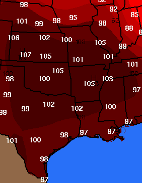
Killer Heat Wave Continues
Temperatures are forecast to be near 100 degrees today through Wednesday across this entire region. This could be one of the most intense heat waves since 1988. Severe drought conditions continue across much of our area and the Southeast United States. No relief is in site. There is a chance for some tropical activity next week. This could be the only hope for substantial rainfall during the short term. The system is too far off to determine the track.
Sunday High Temperature Forecast
Monday High Temperature Forecast
Tuesday High Temperature Forecast
Drought monitor maps show the drought spreading west and northward over the last few weeks. Water shortages are being reported in many areas. Low stream levels are causing problems along with crop failures. A large percentage of the nation is currently reporting below normal rainfall or drought conditions.
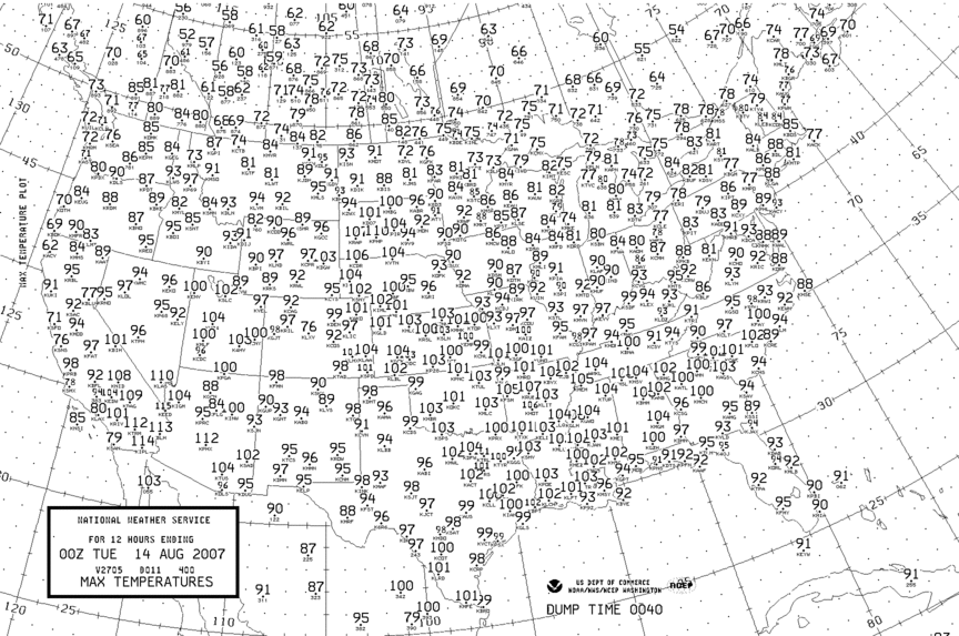
At 3 p.m. it is 100 degrees here in Paducah, Kentucky. Miserable heat.
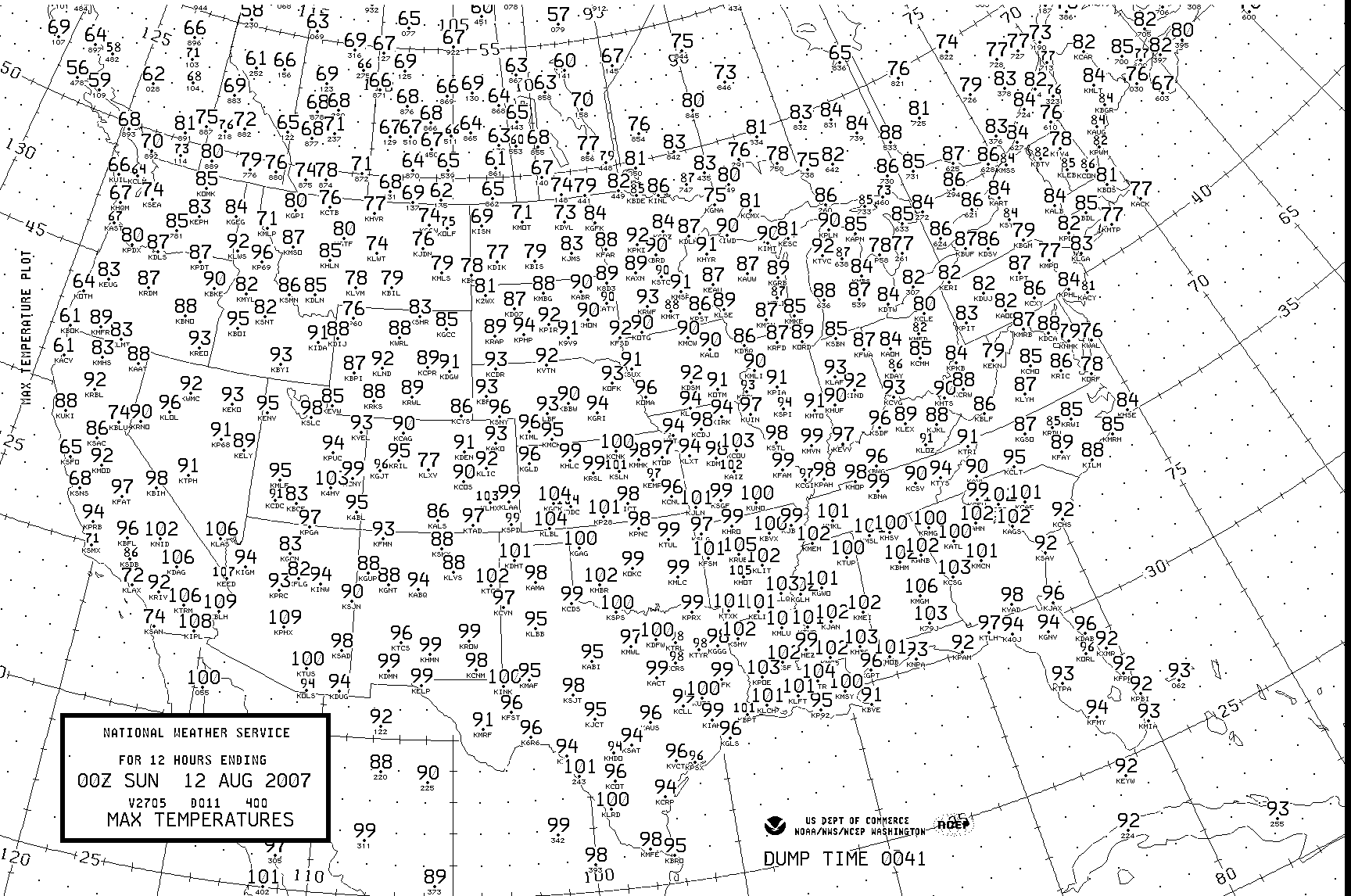

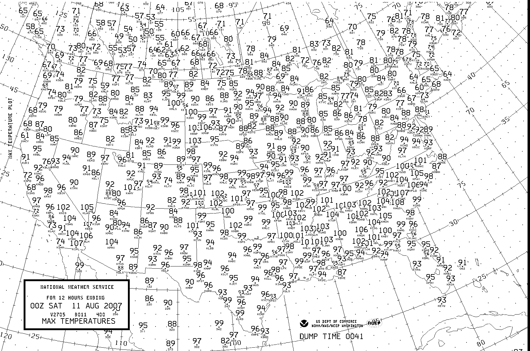
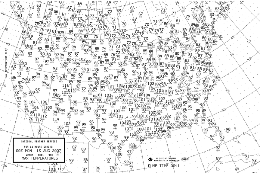
Charts showing Max Temperatures - August 9, 10, 11,
12th.
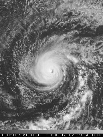
Meanwhile Hurricane Flossie continues to churn southeast of the Hawaiian Islands. Winds this afternoon were estimated to be 140 mph. This makes Flossie a dangerous hurricane. The system should remain south of the islands, however it is possible that tropical storm conditions could threaten the Hawaiian Islands.
Evening mesoscale thunderstorm complex is rolling across Iowa. This complex brought damaging winds to the Omaha, Nebraska Region earlier this evening. Satellite at 9 p.m. is showing an impressive complex.
Click to view large image
August 13, 2007
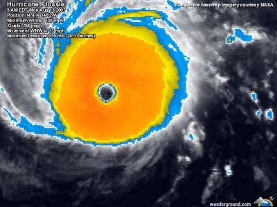
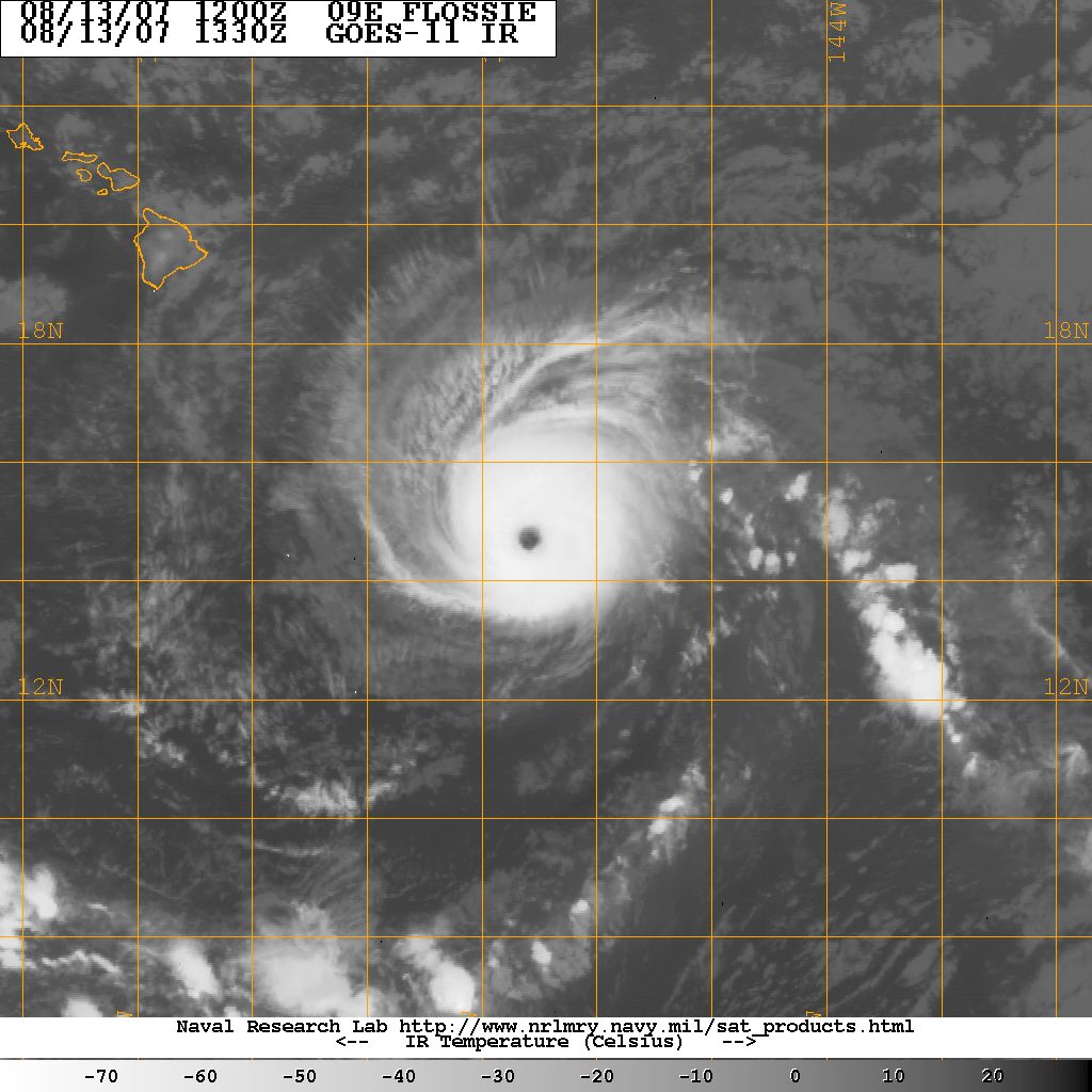
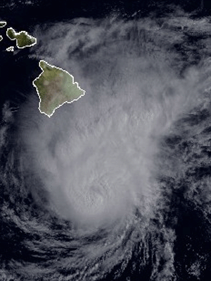
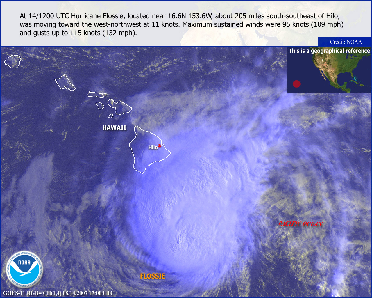
Hurricane Flossie Continues To March Towards Hawaiian Islands.

Click for x-large image of Flossie
Hurricane Flossie, with winds of 135 mph, continues to move towards the
Hawaiian islands. The hurricane will likely impact the islands
during the next couple of days. Strong winds and high surf will
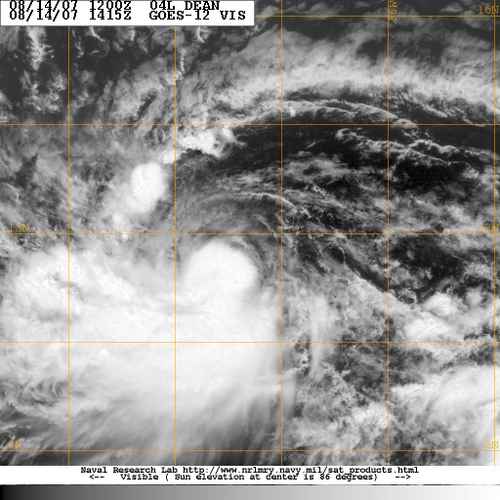
accompany the storm. Meanwhile, in the Atlantic Ocean, a new
tropical depression has formed. This system could develop over the
next few days and strengthen into Tropical Storm Dean. Any impact on
the United States would be more than a week away. At this time it
appears that it might track more south than currently forecast.
The NHC has the movement fairly far north. I believe it could go
further south. Will keep an eye on this developing storm.
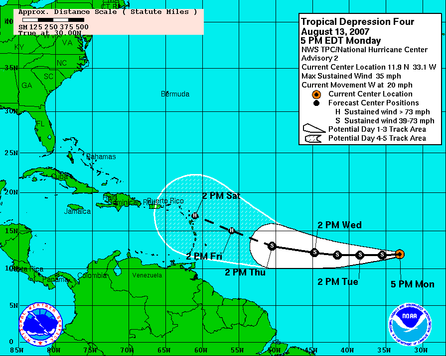
Track Forecast for TD 4
Monday Evening
Tropical storm warnings have been issued for Hawaii. Hurricane watches have also been issued. Tropical storm force winds could impact the island by midday tomorrow. If the storm moves slightly northward then hurricane force winds will be possible across the southern portion of the state.
Monday Evening IR Satellite Image of Flossie


Visible Satellite Images
Heat and humidity continued to plague much of
the Central and Southern United States. Temperatures once again
climbed into the upper nineties and lower one-hundreds across the
region.
High Temperatures
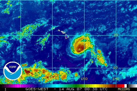
August 14, 2007
Hurricane Flossie Hits Hawaii - Tropical Storm Dean Forms.
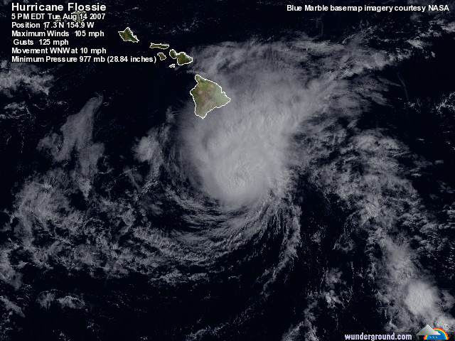
Hurricane Flossie
Hurricane Flossie will impact Hawaii through tonight. The main impact of this hurricane will be gusty winds - near tropical storm force and moderate to heavy rainfall. Most areas will not receive damaging winds. Tropical storm warnings were issued for portions of Hawaii. Meanwhile, in the Atlantic Basin, Tropical Storm Dean has formed. This storm continue to move eastward and should strengthen over the next few days. Dean will likely be a hurricane by the time it arrives in the Caribbean. This system still appears to be moving more south than north. Adjustments to current forecasts will likely be necessary as this movement continues. Flossie does not pose a risk to the United States at this time. We are still 8-10 days away from having to be concerned about a U.S. landfall.
Tropical Storm Dean - Morning
Hurricane Flossie
Hurricane Flossie
Thunderstorms pounded portions of Minnesota and Wisconsin overnight. The most intense storms caused structural damage in Emerald, Wisconsin. Emerald is located in St. Croix County. The NWS had a severe thunderstorm warning in effect at the time of the wind damage. Other areas across Minnesota and Wisconsin reported large hail, damaging winds, and flash flooding.
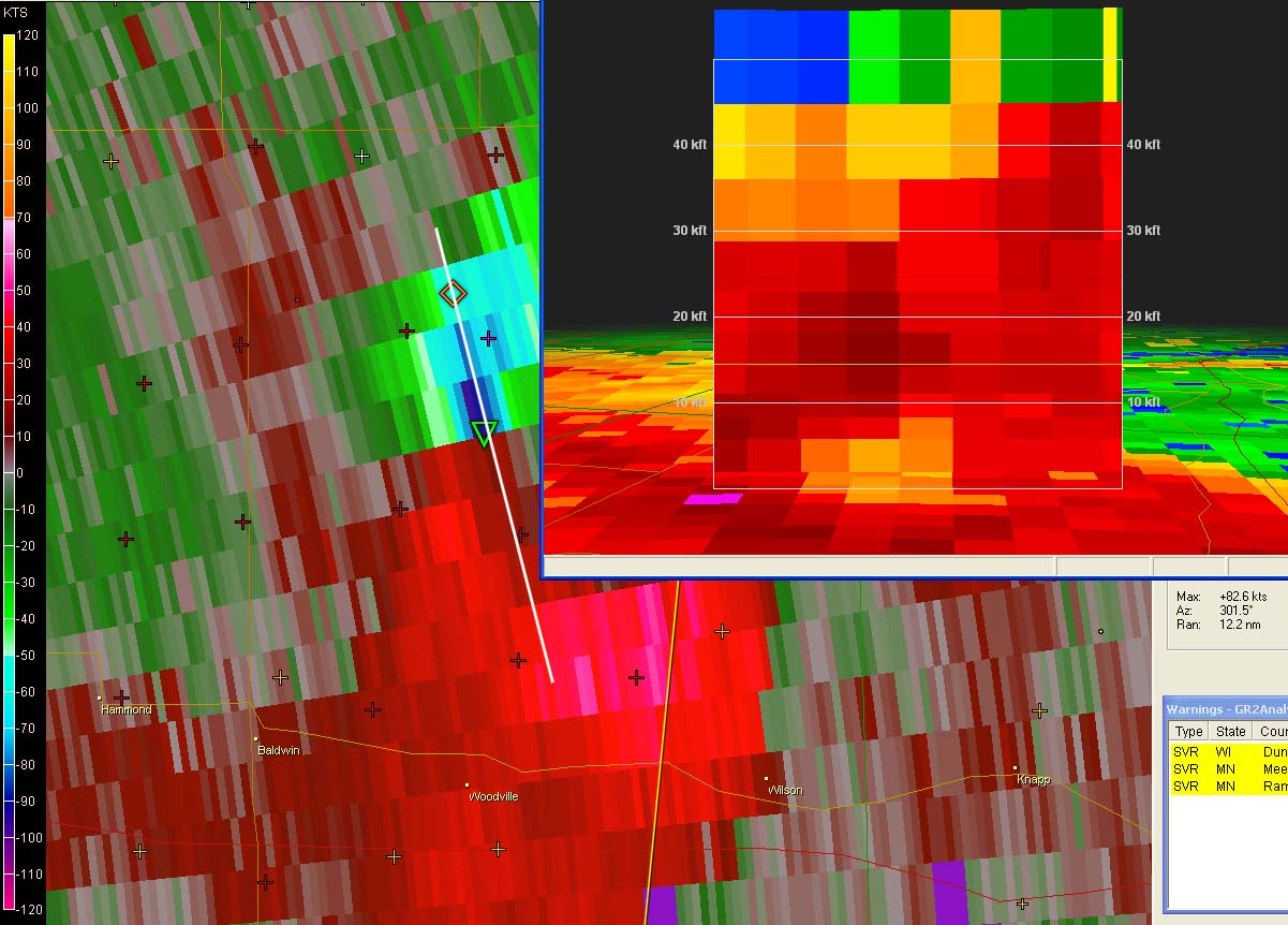
This Gibson Ridge
AE image grab shows the storm that produced the widespread wind
damage. The NWS will be
conducting a storm survey to determine what caused the damage.
Downburst, straight line winds, or a possible tornado. Click on
image for a larger view.
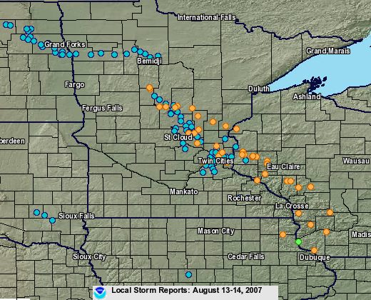
Twin Cities, MN, NWS Storm Damage Reports
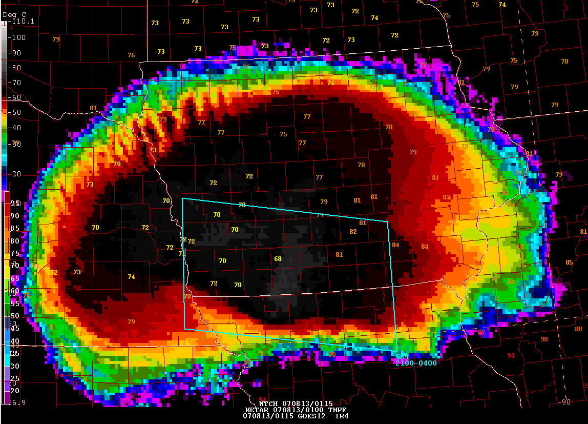
Tuesday Evening - Tropical Depression 5 Develops in the Gulf of Mexico
If all of that wasn't enough for one day we now have tropical depression number 5. The system has formed in the Gulf of Mexico and should move towards Southern Texas and Northern Mexico during the next three days. Intensity models indicate the depression could intensity into a tropical storm. If the depression does strengthen then the name will be Erin. Heavy rainfall and tornadoes will be a good possibility along the track of this tropical system.
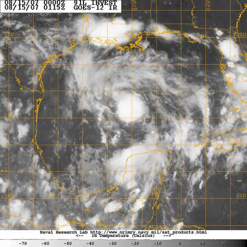
Tropical Depression 5
Turn the page for more weather
Home | About | News | Upcoming Events| Photo Gallery | Video | Links | Contact
All
Photos are copyrighted by Beau Dodson and are used on this site with his
permission. Any use other than authorized is against the law.
If you wish to contact me regarding the use of these photos then
please e-mail me.
Satellite and radar data are provided courtesy of the National Weather
Service and NOAA.