September 6, 2007There are strange drops falling outside my window this morning. I am not sure what to make of this. Upon closer inspection it appears that WATER is falling from the sky. I know it is hard to believe. I checked my sprinklers and they are OFF. This must be what is called rain. I have grabbed my meteorology books and poured through them all morning - yes this is RAIN. A rare watery substance that falls from clouds to the earth below. Don't panic people this is considered NORMAL in some parts of the country. Try to stay calm! Lone Oak picked up 0.32" of rainfall today. The most rain we have had since late July.
Chuck Doswell's Home Page - Want to learn more about the world of meteorology?
One of the pioneers of tornado study, Chuck Doswell has an amazing web-page full of informative commentary and information. You can visit his site at this link. Well worth your time and effort if you are in pursuit of a deeper knowledge about the weather and those who forecast it.
____________________________________________________________ Living in Massac County, Illinois - on top of a hillWhen I was a little boy, I lived on top of a nice hill in Massac County. From this hill you could see the surrounding countryside. Mile after mile of fields, hills, houses, and roads. Perhaps this is one reason that I am so interested in weather today. That and the big blizzards of the late 1970s! I was just a kid when those snowstorms pummeled the Ohio Valley. Even though I was young I will never forget them. Snowdrifts were up and over my head! It was a kids fantasy come true. No school for over a week. More snow than a kid knew what to do with. Trapped in our house unable to get down the snow covered lane. It was a winter wonderland gone wild. In bad weather living on top of a hill is the best, you can see the storms coming and going. The storms would blow in and shake the house with their ferocious winds. I would peer up over the ledge of the window, in my sisters bedroom where we took shelter, and watch the tree in the front yard whipping back and fourth. You could feel the wind on the house. I felt scared and excited at the same time. I loved storms. I have no idea why I loved storms…I just loved them. I loved to watch the lightning late at night while sitting out on the front porch. The warm breeze blowing in my face, the distant rumble of thunder, the sound of rain approaching through the cornfields. All of this helped spark my interested in meteorology. Perhaps one day I can find another hill like that. A place to watch the sun setting in the west…and rising in the east.
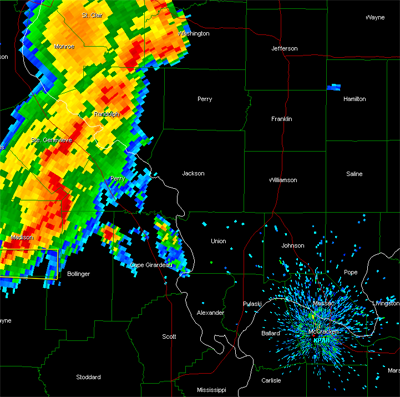
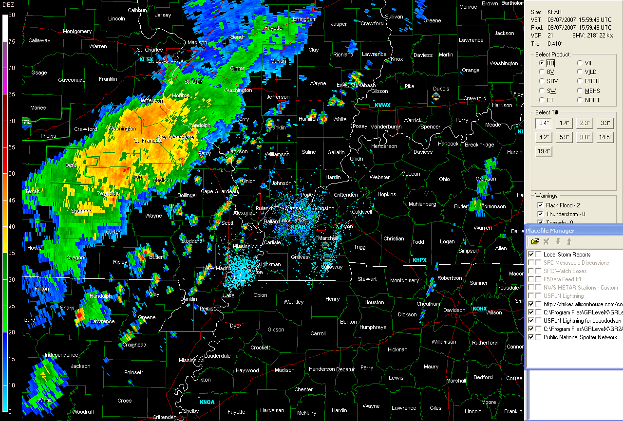
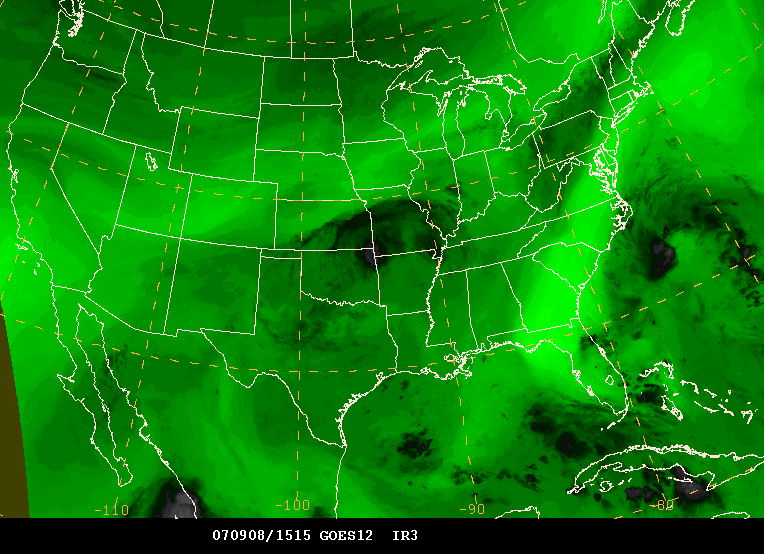
____________________________________________________________ Severe Thunderstorms Approaching Southeast Missouri and Southern Illinois
A line of severe and occasionally tornadic thunderstorms are approaching our western counties. This area of storms should move across Southeast Missouri through the evening and Southern Illinois as well. Portions of Western Kentucky could see activity after 7:30 p.m.
September 7, 2007NOAA Reports La Nina Developing...
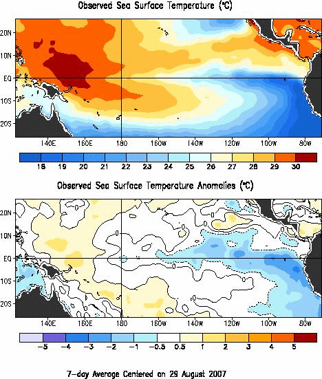
September 6, 2007 — Scientists with NOAA’s Climate Prediction Center, in today’s release of its monthly El Niño/Southern Oscillation (ENSO) Diagnostic Discussion, say that La Niña is on its way. (Click NOAA image for larger view of observed sea surface temperatures on August 29, 2007. Please credit “NOAA.”) “While we can’t officially call it a La Niña yet, we expect that this pattern will continue to develop during the next three months, meeting the NOAA definition for a La Niña event later this year,” said Mike Halpert, acting deputy director of the Climate Prediction Center in Camp Springs, Md. La Niña refers to the periodic cooling of ocean surface temperatures in the central and east-central equatorial Pacific that occur every three to five years. NOAA declares the onset of a La Niña event when the three-month average sea-surface temperature departure exceeds -0.5 degrees Celsius (-0.9 degrees Fahrenheit) in the east-central equatorial Pacific [between 5 degrees North and 5 degrees South and 170 degrees West - 120 degrees West]. More information can be viewed at this web-site.
____________________________________________________________ Peoria, Illinois 2006 - Discovered some photos on my hard-drive.
I found a few more photographs from my Peoria, Illinois Snow Chase - December 1, 2006. You can view all of the photographs by visiting this site - page seven. I can't wait until this chase season begins!
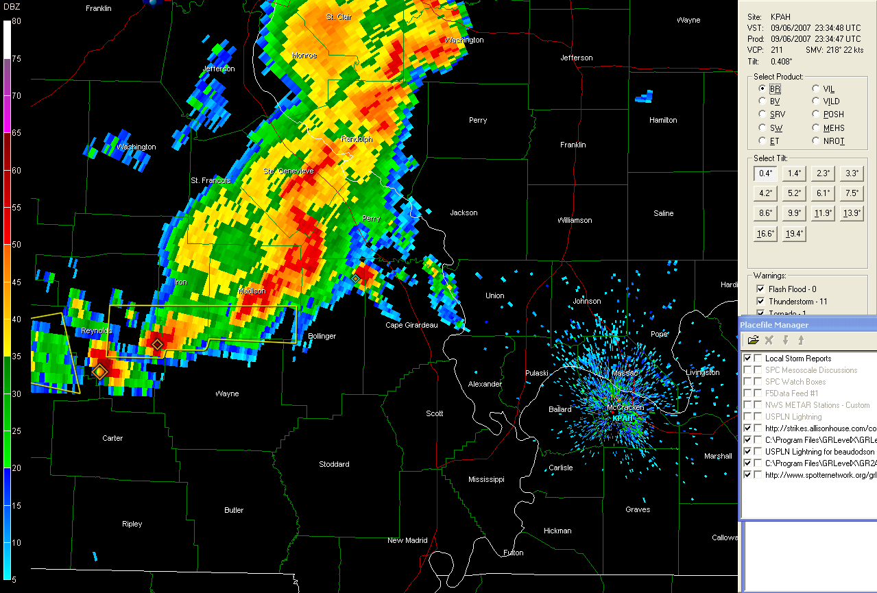
Showers and heavy thunderstorms moving into the region...A large area of showers and thunderstorms is approaching are area from Missouri. This line of storms will continue to push east through the day. Some of the storms could be strong or ever severe with high winds and isolated tornadoes. Heavy rainfall is going to be a threat through the day.
Tropical Depression Forming?
SPECIAL TROPICAL DISTURBANCE STATEMENT
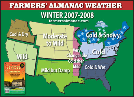
WONT41 KNHC 072106
DSAAT
SPECIAL TROPICAL DISTURBANCE STATEMENT
NWS TPC/NATIONAL HURRICANE CENTER MIAMI FL
505 PM EDT FRI SEP 07 2007
THE AIR FORCE RESERVE HURRICANE HUNTER AIRCRAFT INVESTIGATING THE LOW PRESSURE SYSTEM BETWEEN BERMUDA AND THE SOUTHEAST U.S. COAST HAS NOT YET IDENTIFIED A WELL-DEFINED CLOSED SURFACE CIRCULATION. THE AIRCRAFT WILL CONTINUE TO INVESTIGATE THIS SYSTEM...AND IT COULD BECOME A TROPICAL OR SUBTROPICAL CYCLONE AT ANY TIME AS IT MOVES WEST-NORTHWESTWARD AT ABOUT 10 MPH. INTERESTS ALONG THE SOUTHEAST AND MID-ATLANTIC COAST OF THE U.S. SHOULD CLOSELY MONITOR THE PROGRESS OF THIS SYSTEM...AND TROPICAL STORM WATCHES COULD BE ISSUED THIS EVENING. $$ FORECASTER KNABB Farmers Almanac 2007 - Winter Ahead!Well the Farmers Almanac is out with its WINTER OUTLOOK! Now this is not the Old Farmers Almanac but rather the Farmers Almanac. It sounds like they are going COLD for the Ohio Valley and Northeast. You can view their entire forecast and web site by visiting this link.
“Mother Nature is once again keeping all of us on our
toes,” reveals Editor and Philom.,Peter Geiger, “ we know she
likes to throw curve balls at us from time to time and this
winter it looks as though she’s going to reveal a possible split
personality.” And near and along the boundary zone between the mild,
tranquil West and the cold, stormy East, we look for some
large-scale weather vacillations: from wintry to spring like and
back to wintry, almost like a meteorological pendulum undergoing
a series of pretty wild swings.
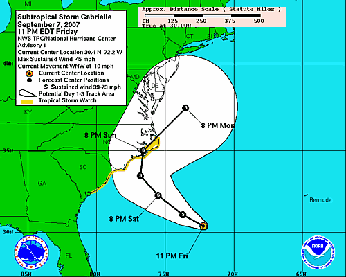
Subtropical Storm Gabrielle Forms off the Southeast Coast...BULLETIN
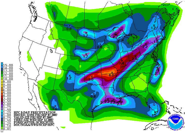
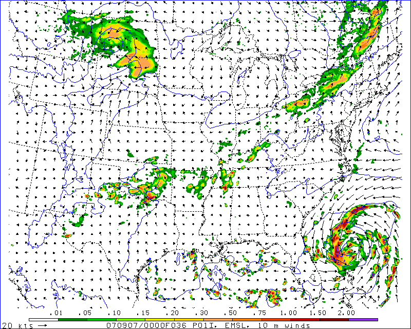
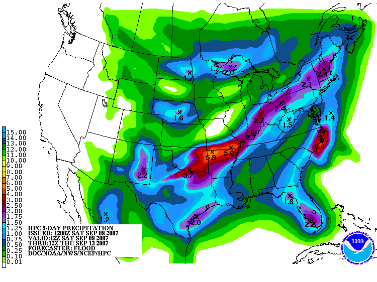
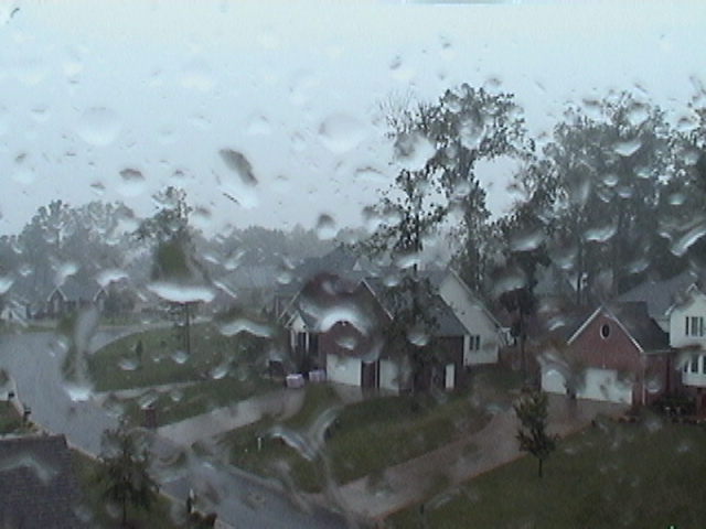
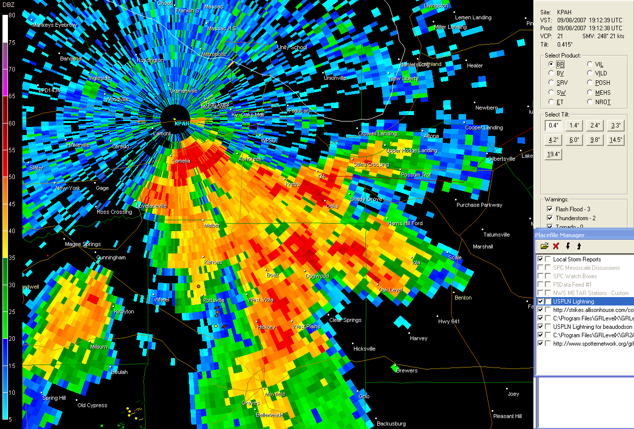
September 8, 2007Extremely heavy rainfall is still falling across portions of Missouri. Some areas have already received 5-10 inches of rain. Incredible amounts for the drought stricken areas. Meanwhile, this area has not received nearly that much. We have picked up less than an inch from this entire event. It appears that heavier rain will be possible today and tonight across Paducah. I will hold out hope that the much need rains will actually make it into my county.
Gabrielle continues to churn off the Southeast Coast...Subtropical Storm Gabrielle continues to move slowly west/northwest towards the Carolinas this morning. Maximum sustained winds are only 45 mph. The main impact from this storm will be beach erosion and some locally heavy rains. A tropical storm warnings has been issued from Surf City North Carolina northward to the North Carolina/Virginia Border.
Rain moving into Lone Oak and Paducah...
There has been a thread started concerning the heavy rainfall across Oklahoma, Missouri, and Illinois. The thread can be found here on EasternUSwx.
____________________________________________________________
Paducah, Kentucky National Weather Service Office Announces A Regional Customer Service Workshop...The
National Weather Service in
Christine Wielgos
|
|
____________________________________________________________ |

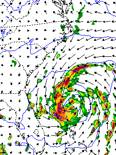
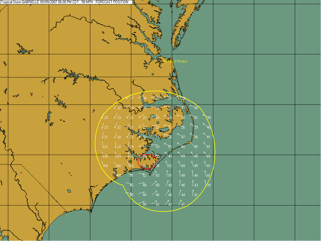
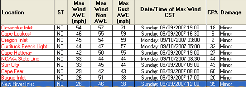
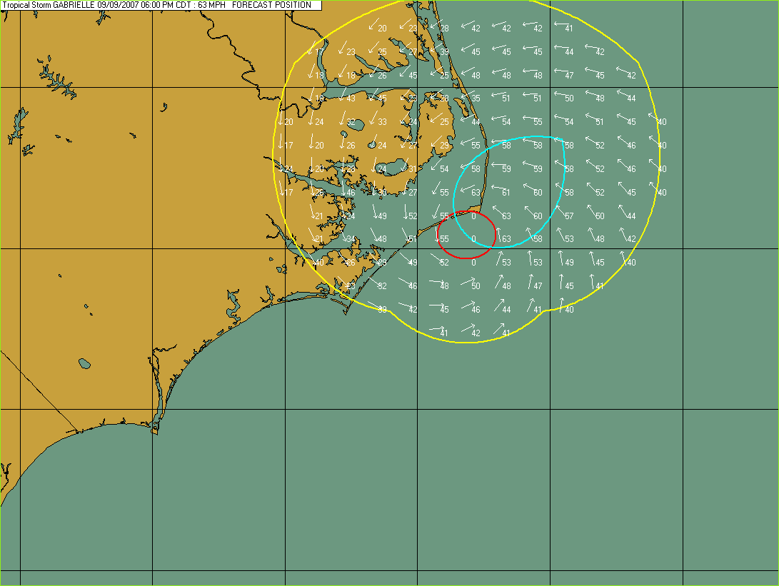

Tropical Storm Gabrielle...evening
Gabrielle continues to move towards the northwest at 12 mph. Outer rainbands are starting to impact the Outer Banks of North Carolina. Winds are only sustained at 40 mph with Gabrielle. Little wind damage impact is expected. Beach erosion and heavy rainfall will likely be the main problems with this system.
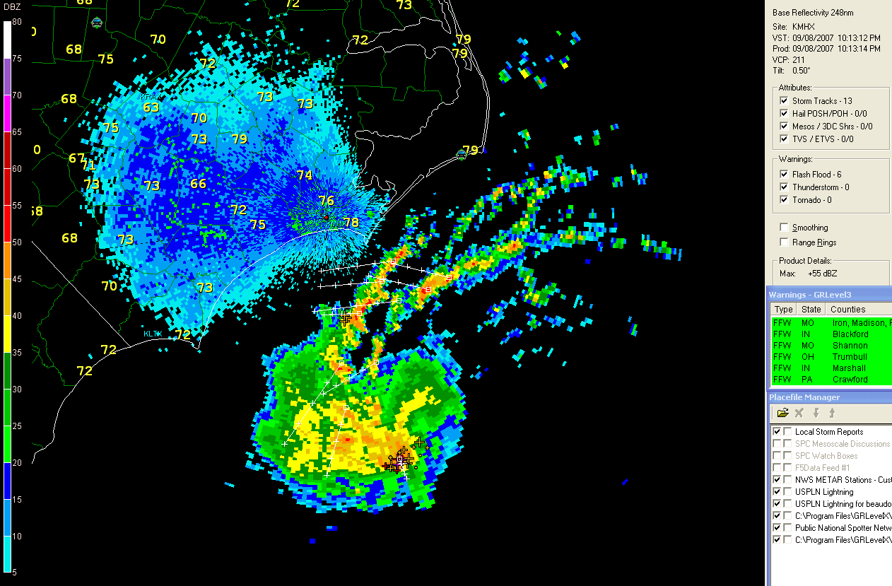
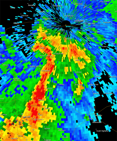
North Carolina Radar
Turn the page for more weather
Home | About | News | Upcoming Events| Photo Gallery | Video | Links | Contact
All Photos are copyrighted by Beau Dodson (unless otherwise clearly stated) and are used on this site with his permission. Any use other than authorized by them is against the law. If you wish to contact him regarding use of these photos, please e-mail me and I will forward it.